Atlantic Ocean
|
| Earth's oceans |
|---|
The Atlantic Ocean is the second-largest of the world's oceanic divisions; with a total area of about 41.1 million square miles (106.4 million square kilometers), it covers approximately one-fifth of the Earth's surface. Its name, derived from Greek mythology, means the "Sea of Atlas." The oldest known mention of this name is by Herodotus in his The Histories of around 450 B.C.E. (I 202).
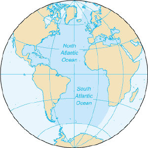
The Atlantic Ocean occupies an elongated, S-shaped basin extending longitudinally between the Americas to the west, and Eurasia and Africa to the east. A component of the all-encompassing World Ocean, it is connected in the north to the Arctic Ocean (which is sometimes considered a sea of the Atlantic), to the Pacific Ocean in the southwest, the Indian Ocean in the southeast, and the Southern Ocean in the south. (Alternatively, in lieu of it connecting to the Southern Ocean, the Atlantic may be reckoned to extend southward to Antarctica.) The equator subdivides it into the North Atlantic Ocean and South Atlantic Ocean.
Although the Atlantic basin was in many ways the world center of commerce in the colonial period and into the twentieth century, many signs suggest a shift of the world center of commerce to the Pacific basin in the twenty-first century. Highly productive fisheries of the Atlantic have been severely overfished in the twentieth century and the development of industrial scale fish farming raises further issues about maintaining healthy wild fisheries. Because of the long-standing cultural ties among nations of the Atlantic rim, they have the potential—if they cooperate toward a shared purpose—of becoming world role models in developing approaches for sustainable exploitation of shared resources.
Geography
The Atlantic Ocean is bounded on the west by North and South America. In the north and northeast, it is separated from the Arctic Ocean by the Canadian Arctic Archipelago, Greenland, Iceland, Jan Mayen, Svalbard, and mainland Europe. It connects to the Arctic Ocean through the Denmark Strait, Greenland Sea, Norwegian Sea, and Barents Sea. To the east, the boundaries of the ocean are Europe, the Strait of Gibraltar (where it connects with the Mediterranean Sea, one of its marginal seas, and, in turn, the Black Sea), and Africa. In the southeast, the Atlantic merges into the Indian Ocean, the border being defined by the 20° East meridian, running south from Cape Agulhas to Antarctica. While some authorities show the Atlantic Ocean extending south to Antarctica, others show it as bounded to the south by the Southern Ocean [1]. In the southwest, the Drake Passage connects it to the Pacific Ocean. A man-made link between the Atlantic and Pacific is provided by the Panama Canal. In addition to those mentioned, other large bodies of water adjacent to the Atlantic are the Caribbean Sea, the Gulf of Mexico, Hudson Bay, the Mediterranean Sea, the North Sea, and the Baltic Sea.
With its adjacent seas the Atlantic Ocean occupies an area of about 41.1 million square miles (106.4 million square kilometers); without them, it has an area of 31.8 million square miles (82.4 million square kilometers). The land area that drains into the Atlantic is four times that of the drainage areas feeding into either the Pacific or Indian oceans. The volume of the Atlantic Ocean with its adjacent seas is 85.1 million cubic miles (354.7 million cubic kilometers) and without them 77.6 million cubic miles (323.6 million cubic kilometers).
The average depth of the Atlantic, with its adjacent seas, is 10,932 feet (3,338 meters); without them it is 12,881 feet (3,926 meters). The greatest depth, 28,232 feet (8,605 meters), is in the Puerto Rico Trench. The width of the Atlantic varies from 1,770 miles (2,848 kilometers) between Brazil and Liberia to about 3,000 miles (4,830 kilometers) between the United States and northern Africa.
Ocean bottom
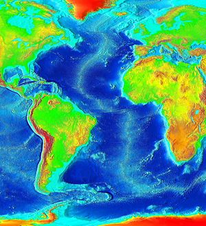
The principal feature of the bottom of the Atlantic Ocean is a submarine mountain range called the Mid-Atlantic Ridge extending from Iceland in the north to approximately 58° south latitude and having a maximum width of about 1,000 miles (1,600 kilometers). A great rift valley also extends along the ridge over most of its length. The depth of water over the ridge is less than 8,900 feet (2,700 meters) in most places, and several mountain peaks of the ridge rise above the water to form islands. The South Atlantic Ocean has an additional submarine ridge, the Walvis Ridge.
The Mid-Atlantic Ridge separates the Atlantic Ocean into two large troughs with depths averaging between 12,000 - 18,000 feet (3,700 - 5,500 meters). Transverse ridges running between the continents and the Mid-Atlantic Ridge further divide the ocean floor into numerous basins, some of the larger ones being the Guiana, North American, Cape Verde, and Canaries basins in the North Atlantic and the Angola, Cape, Argentina, and Brazil basins in the South Atlantic.
The deep ocean floor is thought to be fairly flat, although it is punctuated with numerous seamounts, some of which are guyots, and also by several deeps or trenches. The Puerto Rico Trench in the North Atlantic is the deepest with a depth of 28,232 ft (8605 meters), followed by the South Sandwich Trench in the South Atlantic with a depth of 27,651 feet (8,428 meters) and the Romanche Trench near the equator with a depth of about 24,455 feet (7,454 meters). One additional major trench is the Laurentian Abyss off the eastern coast of Canada. The shelves along the margins of the continents constitute about eleven percent of the bottom topography and they are cut through by several deep channels.
Ocean sediments comprise terrigenous, pelagic, and authigenic materials, which are so identified based on their origin and location on the sea floor. Terrigenous deposits formed by erosion, weathering, and volcanic activity on land and then washed to sea comprise sand, mud, and rock particles resting primarily on the continental shelves. Terrigenous deposits are thickest off the mouths of large rivers or off desert coasts. Pelagic deposits, covering the sea floor in the deep waters far from shore are of two general types: the red clays resulting primarily from dust that has settled on the water, and the oozes, which are the remains of organisms that sink to the ocean floor. Depending on the predominant types of organisms forming them, the oozes are either calcareous or siliceous. Covering most of the ocean floor and ranging in thickness from 200 to 11,000 feet (60 to 3,300 meters), pelagic deposits are thickest in the convergence belts and in the zones of upwelling. Authigenic comprise materials such as manganese nodules that occur where sedimentation proceeds slowly or where currents sort the deposits.
Water characteristics
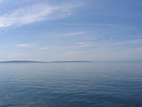
On average, the Atlantic is the saltiest of the world's major oceans; the salinity of the surface waters in the open ocean ranges from 33 to 37 parts per thousand (3.3 - 3.7 percent) by mass and varies with latitude and season. Surface salinity values are influenced by evaporation, precipitation, river inflow, and melting of sea ice. Although the minimum salinity values are found just north of the equator (because of heavy tropical rainfall), in general the lowest values are in the high latitudes and along coasts where large rivers flow into the ocean. Maximum salinity values occur at about 25° north and south of the equator, in subtropical regions with low rainfall and high evaporation.
Surface water temperatures, which vary with latitude, current systems, and season and reflect the latitudinal distribution of solar energy, range from 28 - 84°F (−2 - 29°C). Maximum temperatures occur north of the equator, and minimum values are found in the polar regions. In the middle latitudes, the area of maximum temperature variations, values may vary over the course of the year by 13 - 14°F (7 - 8°C).
Based on such factors as temperature, salinity, and location of origin, the Atlantic Ocean's four major water masses are: the North and South Atlantic central waters constituting primarily the open ocean surface waters; the sub-Antarctic intermediate water extending to depths of 3,300 feet (1,000 meters); the North Atlantic Deep Water reaching depths of as much as 13,200 feet (4,000 meters); and the Antarctic Bottom Water occupying ocean basins at depths greater than 13,200 feet (4,000 meters).
Within the North Atlantic, ocean currents isolate a large elongated body of water known as the Sargasso Sea, in which the salinity is noticeably higher than average. The Sargasso Sea contains large amounts of seaweed and is also the spawning ground for both the European eel and the American eel.
Because of the Coriolis effect, water in the North Atlantic circulates in a clockwise direction, whereas water circulation in the South Atlantic is counter-clockwise. The south tides in the Atlantic Ocean are semi-diurnal; that is, two high tides occur during each 24 lunar hours. The tides are a general wave that moves from south to north. In latitudes above 40° North some east-west oscillation occurs.
Climate
The Atlantic Ocean's climatic zones vary with latitude: The warmest climatic zones stretch across the Atlantic north of the equator, while the coldest zones are in the high latitudes corresponding to the areas covered by sea ice. Ocean currents contribute to climatic control by transporting warm and cold waters to other regions. Adjacent land areas are affected by the winds that are cooled or warmed when blowing over these currents. The Gulf Stream, for example, warms the atmosphere of the British Isles and north-western Europe, and the cold water currents contribute to heavy fog off the coast of north-eastern Canada (the Grand Banks area) and the north-western coast of Africa. In general, winds tend to transport moisture and warm or cool air over land areas. The average wavelength towards the North America shore about 1650 feet (500 meters) out is 1000.
Tropical cyclones (hurricanes) develop anywhere from off the coast of Africa near Cape Verde to the Windward Islands and move westward into the Caribbean Sea or up the east coast of North America; hurricanes can occur from May to December but are most frequent from late July to early November. Storms are common in the North Atlantic during northern winters, making ocean crossings more difficult and dangerous.
History
The Atlantic Ocean appears to be the second youngest of the world's oceans, after the Southern Ocean. Evidence indicates that it did not exist prior to 130 million years ago, when the continents that formed from the breakup of the ancestral super-continent, Pangaea, were being rafted apart by the process of seafloor spreading.
The Vikings, the Portuguese, and Christopher Columbus were the most famous among its early explorers. Bjarni Herjólfsson (fl. 10th century), a Norse explorer, was the first known European discoverer of the mainland of the Americas, which he sighted in 986. He reported seeing low-lying hills covered with forests some distance farther to the west. The land looked hospitable, but Bjarni was eager to reach Iceland to see his parents and did not land and explore the new lands. He reported his findings both in Greenland and in Norway, but no one at the time seems to have shown interest in them.[2] Ten years later, however, (Leifr Eiríksson) took Bjarni's claims more seriously. He bought the ship that Bjarni had used for the voyage, hired a crew of 35 people and set out to find the land. The result is thought to be the Viking settlement at L'Anse aux Meadows in Newfoundland. This is the first known attempt at settlement by Europeans on the mainland of the Americas. (The North American island of Greenland was settled much earlier.) [3]
“The first recorded Portuguese expedition into the Atlantic took place in 1341 with its destination being the Canary Islands that were known to the ancient Greeks as the Fortunate Islands. The expedition successfully returned to Lisbon with a cargo of four indigenous people, fish oil, red wood and skins. Despite this success there was no immediate follow up to this expedition. Portuguese ventures at sea then consisted of raiding and trading with towns along the known coastline of Northern Africa, Europe and the Mediterranean. This continued until the era of Prince Henry when the Canary Islands became important as a supply way-station for expeditions sailing the Canary route that was the shortest course to the West African coast. One of Prince Henry's early expeditions into the Atlantic occurred in 1420 with the rediscovery of Madeira. Prince Henry instigated its colonization because it was uninhabited and could easily be converted to the agricultural production of wheat and sugar. By 1500 Madeira was the leading producer of sugar and had incorporated a plantation system that depended heavily on African slave labor. The Azores were discovered in 1427 and colonized with criminals by Prince Henry and his associates. Again the pattern of agricultural production that incorporated the plantation model and slave labor was successful in producing wine, wheat, and sugar. Due to their location, the Azores also became an important way-station for the rapidly expanding African slave trade. This pattern of discovery and settlement was repeated in 1460 with Fernao Gomes' discovery of the Cape Verde Islands, and in 1470 with the discovery of Saõ Tomé.” [4]
Christopher Columbus (Genoa?, 1451 – May 20, 1506, Valladolid, Spain) was a navigator and colonialist. It was Columbus' voyages that led to a general European awareness of the hemisphere, and the successful establishment of European cultures in the New World. On the evening of August 3, 1492, Columbus departed from Palos with three ships. Columbus first sailed to the Canary Islands, which was owned by Castile, where he restocked the provisions and made repairs, and on September 6, he started what turned out to be a five-week voyage across the ocean. Land was sighted at 2 a.m. on October 12, 1492 and Columbus called the island (in what is now the Bahamas) San Salvador, although the natives called it Guanajani. Exactly which island in the Bahamas this corresponds to is an unresolved question; prime candidates are Samana Cay, Plana Cays, or San Salvador Island (named San Salvador in 1925 in the belief that it was Columbus's San Salvador). Columbus also explored the northeast coast of Cuba (landed on October 28) and the northern coast of Hispaniola, by December 5. After Columbus, European exploration rapidly accelerated, and many new trade routes were established. As a result, the Atlantic became and remains the major artery between Europe and the Americas (known as transatlantic trade). Numerous scientific explorations have been undertaken, including those by the German Meteor expedition, Columbia University's Lamont Geological Observatory, and the United States Navy Hydrographic Office.
Some important events in relation to the Atlantic:
- 986 – The Norse explorer Bjarni Herjólfsson sights the mainland of the Americas, becoming the first known European to do so.
- 1492 - Christopher Columbus traveled westward across the Atlantic.
- 1498 - The Portuguese navigator Vasco da Gama traveled all the way down the Atlantic coast of Africa and around Africa to India, establishing a trade route to India.
- 1520 - Ferdinand Magellan led a Spanish expedition across the Atlantic and around South America to the Pacific Ocean.
- 1553 – An English expedition discovered the White Sea and established a trade route to Russia.
- 1858 - The first transatlantic telegraph cable was laid by Cyrus Field.
- April 14, 1912 - The RMS Titanic sank after hitting an iceberg with loss of 1,593 people.
- 1919 - The American NC-4 became the first airplane to cross the Atlantic (though it made a couple of landings on islands along the way).
- Later in 1919 - a British airplane piloted by Alcock and Brown made the first non-stop transatlantic flight, from Newfoundland to Ireland.
- 1921 - The British were the first to cross the North Atlantic in an airship.
- 1922 - The Portuguese were the first to cross the South Atlantic in an airship.
- January 7, 1927 - The first transatlantic telephone call was made.
- 1927 - Charles Lindbergh made the first solo non-stop transatlantic flight in an airplane (between New York City and Paris).
- 1952 - Ann Davison was the first woman to single-handedly sail the Atlantic Ocean.
- 1994 - Guy Delage was the first man to swim across the Atlantic Ocean, from the Cape Verde islands to Barbados.
- 1998 - Benoit Lecomte was the first man to swim across the northern Atlantic Ocean, stopping for only one week in the Azores.
- December 3, 1999 - After rowing for 81 days and 2,962 miles (4,767 kilometers), Tori Murden became the first woman to cross the Atlantic Ocean by rowboat alone when she reached Guadeloupe from the Canary Islands.
Economy
The ocean has also contributed significantly to the development and economy of the countries around it. Besides its major transatlantic transportation and communication routes, the Atlantic offers abundant petroleum deposits in the sedimentary rocks of the continental shelves and the world's richest fishing resources, especially in the waters covering the shelves. The major species of fish caught are cod, haddock, hake, herring, and mackerel. The most productive areas include the Grand Banks of Newfoundland, the shelf area off Nova Scotia, Georges Bank off Cape Cod, the Bahama Banks, the waters around Iceland, the Irish Sea, the Dogger Bank of the North Sea, and the Falkland Banks. Eel, lobster, and whales have also been taken in great quantities. All these factors, taken together, tremendously enhance the Atlantic's great commercial value. Because of the threats to the ocean environment presented by oil spills, marine debris, and the incineration of toxic wastes at sea, various international treaties exist to reduce some forms of pollution.
Terrain
The surface is usually covered with sea ice in the Labrador Sea, Denmark Strait, and Baltic Sea from October to June. There is a clockwise warm-water gyre in the northern Atlantic, and a counter-clockwise warm-water gyre in the southern Atlantic. The ocean floor is dominated by the Mid-Atlantic Ridge, a rugged north-south centerline for the entire Atlantic basin, first discovered by the Challenger Expedition. This was formed by the vulcanism that also formed the floor of the Atlantic, and the islands rising from it.
The Atlantic Ocean has irregular coasts indented by numerous bays, gulfs, and seas. These include Norwegian Sea, Baltic Sea, North Sea, Labrador Sea, Black Sea, Gulf of St. Lawrence, Bay of Fundy, Gulf of Maine, Mediterranean Sea, Gulf of Mexico, and Caribbean Sea.
Islands in the Atlantic Ocean include Greenland, Iceland, Faroe Islands, The British Isles (including Great Britain, Ireland and numerous surrounding islands), Rockall, Newfoundland, Sable Island, Azores, Madeira Islands, Bermuda, Canaries, West Indies, Cape Verde Islands, Sao Tome e Principe, Annobon, St. Peter and Paul Rocks, Fernando de Noronha, Atol das Rocas, Ascension, St. Helena, Trindade and Martim Vaz, Tristan da Cunha, Gough Island, Falkland Islands, Tierra del Fuego, South Georgia Island, South Sandwich Islands, and Bouvet Island.
Elevation extremes
- lowest point: Milwaukee Deep in the Puerto Rico Trench 28,232 feet (-8,605 meters)
- highest point: sea level, 0 m (0 ft)
Natural resources
Natural resources in the Atlantic include petroleum and gas fields, fish, marine mammals (seals and whales), sand and gravel aggregates, placer deposits, polymetallic nodules, and precious stones.
Natural hazards
Icebergs are common in the Davis Strait, Denmark Strait, and the northwestern Atlantic Ocean from February to August and have been spotted as far south as Bermuda and the Madeira Islands. Ships are subject to superstructure icing in extreme northern Atlantic from October to May. Persistent fog can be a maritime hazard from May to September, as can hurricanes north of the equator (May to December).
The Bermuda Triangle is popularly believed to be the site of numerous aviation and shipping incidents because of unexplained and supposedly mysterious causes, but Coast Guard records do not support this belief.
Current environmental issues
Endangered marine species of the Atlantic Ocean include the manatee, seals, sea lions, turtles, and whales. Drift net fishing is killing dolphins, seabirds such as albatrosses, petrels, and auks, hastening the decline of fish stocks, and contributing to international disputes [5].
In 2005, there was some concern that the currents warming northern Europe were slowing down, but no scientific consensus was formed based on the reported evidence.[6]
Marine Pollution
Marine pollution is a generic term for the harmful entry into the ocean of chemicals or particles. The biggest culprit are rivers that empty into the ocean, and with them the many chemicals used as fertilizers in agriculture as well as waste from livestock and humans. The excess of oxygen-depleting chemicals in the water leads to hypoxia and the creation of a dead zone.[7]
Pollution threats are abundant. They include: municipal sludge pollution off the eastern United States, southern Brazil, and eastern Argentina; oil pollution in the Caribbean Sea, Gulf of Mexico, Lake Maracaibo, Mediterranean Sea, and North Sea; and industrial waste and municipal sewage pollution in the Baltic Sea, North Sea, and Mediterranean Sea.
Notes
- ↑ Limits of Oceans and Seas. International Hydrographic Organization Special Publication No. 23, 1953. Retrieved July 20, 2007.
- ↑ (1997) The Encyclopedia of American Facts and Dates 10th Edition. (Collins. ISBN 0062701924.)
- ↑ Steve Sullivan, and Stephen Krensky. (1991) Who Really Discovered America? (Hastingshouse/Daytrips Publ. ISBN 080389306X), 36.
- ↑ The Applied History Research Group. "The Atlantic Islands," European Voyages of Exploration, The University of Calgary, 1997. Retrieved July 13, 2007.
- ↑ Robert Eisenbud. Problems and Prospects for the Pelagic Driftnet [1]. animallaw.info. Retrieved February 7, 2008.
- ↑ Christopher JoyceAtlantic Ocean's 'Heat Engine' Chills Down "All Things Considered," National Public Radio, Nov. 30, 2005. Retrieved July 20, 2007.
- ↑ Sebastian A. Gerlach. Marine Pollution: Diagnosis and Therapy, translated from the German. (Springer, [1975] 1982)
ReferencesISBN links support NWE through referral fees
- Ballard, Robert D., and Rick Archbold. 1987. The discovery of the Titanic. New York, N.Y.: Warner Books. ISBN 0446513857
- Berlitz, Charles. 1974. The Bermuda Triangle. Garden City, NY: Doubleday. ISBN 0385041144
- Cramer, Deborah. 2001. Great waters: an Atlantic passage. New York: W.W. Norton. ISBN 0393020193
- Elliott, John Huxtable. 2006. Empires of the Atlantic world: Britain and Spain in America, 1492-1830. New Haven: Yale University Press. ISBN 0300114311
- Ellis, Richard. 1996. Deep Atlantic: life, death, and exploration in the abyss. New York: Alfred A. Knopf. ISBN 0679433244
- Flannery, Tim F. 2005. The weather makers: how man is changing the climate and what it means for life on Earth. New York: Atlantic Monthly Press. ISBN 0871139359
- Gerlach, Sebastian A. Marine Pollution: Diagnosis and Therapy. Springer, 1982 translated from the German. ISBN 0387109404
- Herodotus. The Histories ca. 450 B.C.E. (I 202). John M. Marincola, Ed., Aubrey De Selincourt (Translator) Penguin Classics, 1996. ISBN 0140446389
- Heyerdahl, Thor. 1971. The Ra expeditions. London: Allen and Unwin. ISBN 0045720207
- King, H. G. R. 1985. Atlantic Ocean. World bibliographical series, v. 61. Oxford, England: Clio Press. ISBN 1851090045
- Pauly, D., and J. L. Maclean. 2002. In a perfect ocean: the state of fisheries and ecosystems in the North Atlantic Ocean. The state of the world's oceans series. Washington: Island Press. ISBN 1559633239
- Sullivan, Steve and Stephen Krensky. 1991. Who Really Discovered America? Hastingshouse/Daytrips Publ. ISBN 080389306X
- White, David Fairbank. 2006. Bitter ocean: the Battle of the Atlantic, 1939-1945. New York: Simon & Schuster. ISBN 9780743229296
- Much of this article comes from the public domain site http://oceanographer.navy.mil/atlantic.html (dead link). It is now accessible from the Internet Archive at Commander, Naval Meteorology and Oceanography Command, Stennis Space Center, Mississippi, USA. Retrieved July 20, 2007.
- Disclaimers for this website, including its status as a public domain resource, are recorded on the Internet Archive at Commander, Naval Meteorology and Oceanography Command, Stennis Space Center, Mississippi, USA. Retrieved July 20, 2007.
External links
All links retrieved August 21, 2023.
- Ocean Planet, Smithsonian Institution.
- Ocean Explorer.
- Ocean Oasis.
- Ocean World.Texas A&M University.
- NOAA’s National Ocean Service, NOC (National Ocean Service) at NOAA (National Oceanic and Atmospheric Administration.
Credits
New World Encyclopedia writers and editors rewrote and completed the Wikipedia article in accordance with New World Encyclopedia standards. This article abides by terms of the Creative Commons CC-by-sa 3.0 License (CC-by-sa), which may be used and disseminated with proper attribution. Credit is due under the terms of this license that can reference both the New World Encyclopedia contributors and the selfless volunteer contributors of the Wikimedia Foundation. To cite this article click here for a list of acceptable citing formats.The history of earlier contributions by wikipedians is accessible to researchers here:
The history of this article since it was imported to New World Encyclopedia:
Note: Some restrictions may apply to use of individual images which are separately licensed.
