Guatemala
| República de Guatemala (Spanish) Republic of Guatemala | |||||
| |||||
| Motto: El País de la Eterna Primavera "Land of Eternal Spring" | |||||
| Anthem: Himno Nacional de Guatemala | |||||
| Capital (and largest city) |
Guatemala City 14°38′N 90°30′W | ||||
| Official languages | Spanish, 22 indigenous languages: | ||||
|---|---|---|---|---|---|
| Government | Unitary Presidential republic | ||||
| - President | Bernardo Arévalo | ||||
| - Vice President | Karin Herrera | ||||
| Independence | from Spain | ||||
| - Declared (independence from Spain) | 15 September 1821 | ||||
| - Recognized by Spain | 25 July 1850 | ||||
| - from the First Mexican Empire | July 1, 1823 | ||||
| Area | |||||
| - Total | 108,890 km² (105th) 42,042 sq mi | ||||
| - Water (%) | 0.4 | ||||
| Population | |||||
| - 2023 estimate | 17,980,803[1] | ||||
| - Density | 129/km² 348.6/sq mi | ||||
| GDP (PPP) | 2024 estimate | ||||
| - Total | |||||
| - Per capita | |||||
| GDP (nominal) | 2024 estimate | ||||
| - Total | |||||
| - Per capita | |||||
| HDI (2021) | |||||
| Currency | Quetzal (GTQ)
| ||||
| Time zone | Central Time (UTC-6) | ||||
| Internet TLD | .gt | ||||
| Calling code | ++502 | ||||
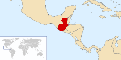
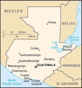
The Republic of Guatemala (Spanish: República de Guatemala, IPA: [re'puβlika ðe ɣwate'mala]), is a country in Central America bordered by Mexico to the northwest, the Pacific Ocean to the southwest, Belize and the Caribbean Sea to the northeast, and Honduras and El Salvador to the southeast.
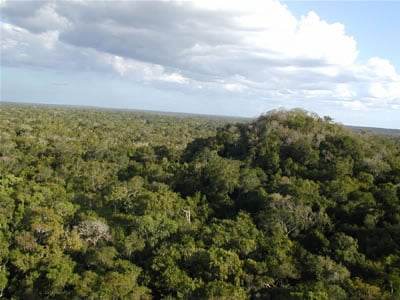
The most populous nation in Central America, Guatemala is a representative democracy with its capital at Guatemala City. Although the nation has been relatively stable since 1996, Guatemala's recent history has been plagued by civil war and military coups, which have slowed the nation's development. Large portions of Guatemala's interior remain wholly undeveloped, including the nation's many rainforests and wetlands. Guatemala's abundance of biologically significant and unique ecosystems contribute to Mesoamerica's designation as an important biodiversity hotspot.
The country name comes from the Nahuatl Cuauhtēmallān, "place of many trees," a translation of K'iche' Mayan K’ii’chee’, "many trees" (that is, "forest").[4]
Geography
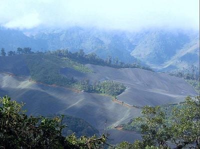
Guatemala is about the size of the U.S. state of Tennessee. About two thirds of Guatemala is mountainous, except for the south coastal area and the northern vast lowlands of the Petén department. Two mountain chains enter Guatemala from west to east, dividing the country into three major regions:
- the highlands, where the mountains are located;
- the Pacific coast, south of the mountains; and
- the Petén region, north of the mountains.
All major cities are located in the highlands and Pacific coast regions; by comparison, Petén is sparsely populated. These three regions vary in climate, elevation, and landscape, providing dramatic contrasts between hot and humid tropical lowlands and colder and drier highland peaks. Volcán Tajumulco, at 4,220 meters, is the highest point in Central America.
The rivers are short and shallow in the Pacific region, larger and deeper, such as the Polochic which drains in Lake Izabal Río Dulce, (Motagua) and Sartún that forms the boundary with Belize in the Caribbean and the Gulf of Mexico region (Usumacinta, which forms the boundary between Chiapas, Mexico and Petén and its tributaries such as La Pasión and San Pedro.
Natural disasters
Guatemala's location on the Caribbean Sea and Pacific Ocean makes it a target for hurricanes, such as Hurricane Mitch in 1998 and Hurricane Stan in 2005, which killed more than 1,500 people. Much of the damage was not wind related, but rather due to significant flooding and landslides.
Guatemala's highlands lie atop the boundary between the Caribbean and North American tectonic plates, and thus are subject to frequent earthquakes and volcanic activity. Guatemala has 37 volcanoes, four of them active: Pacaya, Santiaguito, Fuego and Tacaná. The last major earthquake was in February 1976, killing more than 25,000 in the Central Highlands.
On June 13, 2007 a 6.8 Magnitude earthquake hit the pacific coast of Guatemala, but there were no reports of death or major damage. It lasted for 30 seconds and was the second earthquake that occurred in a week. The one before was June 8, which was a 5.9 Magnitude earthquake.
Biodiversity
Guatemala has 14 eco-regions ranging from mangrove forest (four species), to both ocean littorals with five different ecosystems, dry forest and thorn bushes in the Eastern Highlands, subtropical and tropical rain forest, wetlands, cloud humid forest in the Verapaz region, mix and pine forest in the Highlands. Over 36 percent, or about 39,380 km² of Guatemala is forested. Of this, 49.7 percent or roughly 19,570 km² is classified as primary forest, the most biodiverse form of forest, including 17 Conifer (pine, cypress and the endemic Abies Guatemalensis) species, the most in any tropical region of the world.
There are 252 listed wetlands in the country, including five lakes, 61 lagoons, 100 rivers, and three swamps. Six of those wetlands are of international importance or RAMSAR sites. Tikal National Park was the first mixed UNESCO World Heritage Site in the world, inscribed according to both natural and cultural criteria.[5]
Guatemala has some 1,246 known species of amphibians, birds, mammals and reptiles according to figures from the World Conservation Monitoring Centre. Of these, 6.7 percent are endemic, meaning they exist in no other country, and 8.1 percent are threatened species. Guatemala is home to at least 8,681 species of vascular plants, of which 13.5 percent are endemic. 5.4 percent of Guatemala is protected under IUCN categories I-V and has the largest percentage of Protected areas in Central America, with a total of 91 protected areas and more than 30 percent of the territory as a protected area. [6]
History
Pre-Columbian
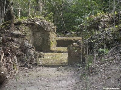
Archaeologists divide the pre-Columbian history of Mesoamerica into three periods: The Pre-Classic from 2000 B.C.E. to 250 C.E., the Classic from 250 to 900 C.E., and the Post-Classic from 900 to 1500 C.E. Until recently, the Pre-Classic was regarded as a formative period, with small villages of farmers who lived in huts, and few permanent buildings, but this notion has been challenged by recent discoveries of monumental architecture from that period, such as an altar in La Blanca, San Marcos, some three meters in diameter, dating from 1000 B.C.E., ceremonial sites at Miraflores and El Naranjo from 800 B.C.E., and the Mirador Basin cities of Nakbé, Xulnal, Tintal, Wakná and El Mirador.
El Mirador was by far the most populated city in the pre-Columbian America, and contained the largest pyramid in the world, at 2,800,000 cubic meters in volume (some 200,000 more than the Great Pyramid of Giza in Egypt). Mirador was the first politically organized state in America, named the Kan Kingdom in ancient texts. There were 26 cities, all connected by highways, which were several kilometers long, up to 40 meters wide, and two to four meters above the ground, paved with stucco, that are clearly distinguishable from the air in the most extensive virgin tropical rain forest in Mesoamerica.
The Classic period of Mesoamerican civilization corresponds to the height of the Maya civilization, and is represented by countless sites throughout Guatemala, although the largest concentration is in Petén. This period is characterized by heavy city-building, the development of independent city-states, and contact with other Mesoamerican cultures.
This lasted until around 900 B.C.E., when, for reasons not understood by archaeologists, the Maya went into decline and abandoned many of the cities of the central lowlands. The Post-Classic period is represented by regional kingdoms such as the Itzá and Ko'woj in the Lakes area in Petén, and the Mam, Ki'ch'es, Kack'chiquel, Tz'utuh'il, Pokom'chí, Kek'chi and Chortí in the Highlands. These cities preserved many aspects of Mayan culture, but would never equal the size or power of the Classic cities.
Colonial
After discovering the New World, the Spanish mounted several peaceful expeditions to Guatemala beginning in 1518. Before long, Spanish contact resulted in an epidemic that devastated native populations (believed to be smallpox, based on the description in the "Memorial de Sololá."
Hernándo Cortés, who had led the Spanish conquest of Mexico, granted a permit to Captain Pedro de Alvarado, to conquer this land. Alvarado at first allied himself with the Cakchiquel nation to fight against their traditional rivals, the Quiché nation. Alvarado later turned against the Cakchiquels, and eventually held the entire region under Spanish domination.
During the colonial period, Guatemala was a Captaincy General of Spain, and a part of New Spain (Mexico). It extended from the Soconusco region - now in southern Mexico (states of Chiapas, Tabasco) - to Costa Rica. This region was not as rich in (gold and silver) as Mexico and Peru, and was therefore not considered to be as important. Its main products were sugarcane, cocoa, blue añil dye, red dye from cochineal insects, and precious woods used in artwork for churches and palaces in Spain.
The first capital was named Tecpan Guatemala, founded in 1524 with the name of Villa de Santiago de Guatemala and was located near Iximché, the Cakchiquel's capital city. It was moved to Ciudad Vieja in November 1527, when the Cakchiquel attacked the city. In 1541 the city was flooded when the lagoon in the crater of the Agua Volcano collapsed due to heavy rains and earthquakes, and was moved 4 miles to Antigua Guatemala, on the Panchoy Valley, now a UNESCO World Heritage Site. This city was destroyed by several earthquakes in 1773-1774, and the King of Spain granted the authorization to move the Captaincy General to the Ermita Valley, named after a Catholic Church to the Virgen de El Carmen, in its current location, founded in January 2, 1776.
Independence
On September 15, 1821, Guatemala declared itself independent from Spain, and on October 3, 1821, the Captaincy-General of Guatemala, (formed by Chiapas, Guatemala, El Salvador, Nicaragua, Costa Rica and Honduras) officially proclaimed its independence from Spain and its incorporation into the Mexican Empire. This region had been formally subject to New Spain throughout the colonial period, but as a practical matter was administered separately. All but Chiapas soon separated from Mexico after Agustín I from Mexico was forced to abdicate.
The Guatemalan provinces formed the United Provinces of Central America, also called the Central American Federation (Federacion de Estados Centroamericanos).
Guatemala has long claimed all or part of the territory of neighboring Belize, formerly part of the Spanish colony, and currently an independent Commonwealth Realm which recognizes Queen Elizabeth II of the United Kingdom as its Head of State. Guatemala recognized Belize's independence in 1990, but their territorial dispute is not resolved. Negotiations are currently underway under the auspices of the Organization of American States and the Commonwealth of Nations to conclude it. [7]
The Modern fight for a nation
On July 4, 1944, dictator Jorge Ubico Castañeda was forced to resign office in response to a wave of protests and a general strike. His replacement, General Juan Federico Ponce Vaides, was forced out of office on October 20, 1944 by a coup d'état led by Major Francisco Javier Arana and Captain Jacobo Arbenz Guzmán. About 100 people were killed in the coup. The country was then led by a military junta made up of Arana, Arbenz, and Jorge Toriello Garrido. The Junta called Guatemala's first free election, which was won with a majority of 85 percent by the prominent writer and teacher Juan José Arévalo Bermejo, who had lived in exile in Argentina for 14 years. Arévalo was the first democratically elected president of Guatemala to fully complete the term for which he was elected. His "Christian Socialist" policies, inspired by the U.S. New Deal, were criticized by landowners and the upper class as "communist."
This period was also the beginning of the Cold War between the U.S. and the Soviet Union, which was to have a considerable influence on Guatemalan history. From the 1950s through the 1990s, the U.S. government directly supported Guatemala's army with training, weapons, and money in an effort to stem the spread of communism in the region.
In 1954, Arévalo's freely elected Guatemalan successor, Jacobo Arbenz, was overthrown by the U.S. Central Intelligence Agency (CIA) and a small group of Guatemalans (landowners, the old military caste, and the Catholic Church), after the government instituted a decree which expropriated large tracts of land owned by the United Fruit Company, a U.S.-based banana merchant (Chiquita Banana). The CIA codename for the coup was Operation PBSUCCESS (it was the CIA's second successful overthrow of a foreign government after the 1953 coup in Iran). Colonel Carlos Castillo Armas was installed as president in 1954 and ruled until he was assassinated by a member of his personal guard in 1957.
In the election that followed, General Miguel Ydígoras Fuentes assumed power. Ydigoras authorized the training of 5,000 anti-Castro Cubans in Guatemala. He also provided airstrips in the region of Petén for what later became the failed Bay of Pigs Invasion in 1961. Ydigoras' government was ousted in 1963 when the Air Force attacked several military bases. The coup was led by his Defense Minister, Colonel Enrique Peralta Azurdia.
In 1966, Julio César Méndez Montenegro was elected president of Guatemala under the banner "Democratic Opening." Mendez Montenegro was the candidate of the Revolutionary Party, a center-left party which had its origins in the post-Ubico era. It was during this time that rightist paramilitary organizations, such as the "White Hand" (Mano Blanca), and the Anticommunist Secret Army, (Ejército Secreto Anticomunista), were formed. Those organizations were the forerunners of the infamous "Death Squads." Military advisers of the United States Army Special Forces (Green Berets) were sent to Guatemala to train troops and help transform its army into a modern counter-insurgency force, which eventually made it the most sophisticated in Central America.
In 1970, Colonel Carlos Manuel Arana Osorio was elected president. A new guerrilla movement entered the country from Mexico, into the Western Highlands in 1972. In the disputed election of 1974, General Kjell Lauguerud García defeated General Efraín Ríos Montt, a candidate of the Christian Democratic Party, who claimed that he had been cheated out of a victory through fraud.
On February 4, 1976, a major earthquake destroyed several cities and caused more than 25,000 deaths. In 1978, in a fraudulent election, General Romeo Lucas García assumed power. The 1970s saw the birth of two new guerrilla organizations, The Poor Guerrilla Army (EGP) and the Organization of the Peoples in Arms (ORPA), who began and intensified by the end of the 1970s guerrilla attacks that included urban and rural guerrilla warfare, mainly against the military and some of the civilian supporters of the army. In 1979, the United States president, Jimmy Carter, ordered a ban on all military aid to the Guatemalan Army because of the widespread and systematic abuse of human rights. Almost immediately, the Israeli Government took over supplying the Guatemalan Army with advisers, weapons and other military supplies.
In 1980, a group of Quiché Indians took over the Spanish Embassy to protest army massacres in the countryside. The Guatemalan government launched an assault that killed almost everyone inside as a result of a fire that consumed the building. The Guatemalan government claimed that the activists set the fire and immolated themselves. However, the Spanish ambassador, who survived the fire, disputed this claim, noting that the Guatemalan police intentionally killed almost everyone inside and set the fire to erase traces of their acts. As a result of this incident, the government of Spain broke diplomatic relations with Guatemala. This government was overthrown in 1982. General Efraín Ríos Montt was named President of the military junta, continuing the bloody campaign of torture, disappearances, and "scorched earth" warfare. The country became a pariah state internationally. Ríos Montt was overthrown by General Óscar Humberto Mejía Victores, who called for an election of a national constitutional assembly to write a new constitution, leading to a free election in 1986, which was won by Vinicio Cerezo Arévalo, the candidate of the Christian Democracy Party.
In 1982, the four guerrilla groups, EGP, ORPA, FAR and PGT, merged and formed the URNG, influenced by the Salvadoran guerrilla FMLN, the Nicaraguan FSLN and Cuba's government, in order to become stronger. As a result of the army's "scorched earth" tactics in the countryside, more than 45,000 Guatemalans fled across the border to Mexico. The Mexican government placed the refugees in camps in Chiapas and Tabasco.
In 1992, the Nobel Peace Prize was awarded to Rigoberta Menchú for her efforts to bring international attention to the government-sponsored genocide against the indigenous population.
The bloody 35-year old war of repression ended in 1996 with a peace accord between the guerrillas and the government of President Álvaro Arzú, negotiated by the United Nations through intense brokerage by nations such as Norway and Spain. Both sides made major concessions. The guerrilla fighters disarmed and received land to work. According to the U.N.-sponsored truth commission (styled the "Commission for Historical Clarification"), government forces and state-sponsored paramilitaries were responsible for over 93 percent of the human rights violations during the war.[8]
During the first ten years, the victims of the state-sponsored terror were primarily students, workers, professionals, and opposition figures, but in the last years they were thousands of mostly rural Mayan farmers and non-combatants. More than 450 Mayan villages were destroyed and over one million people became internal and external refugees. In certain areas, such as Baja Verapaz, the Truth Commission considered that the Guatemalan state engaged in an intentional policy of genocide against particular ethnic groups during the Civil War.[8] In 1999, U.S. president Bill Clinton stated that the United States was wrong to have provided support to Guatemalan military forces that took part in the brutal civilian killings. [9]
Since the peace accords, Guatemala has witnessed successive democratic elections. The past government has signed free trade agreements with the rest of Central America through CAFTA, and other agreements with Mexico. In the 2007 elections, El Partido Nacional de la Esperanza and its president candidate Álvaro Colom won the presidency as well as the majority of the seats in congress.
Politics
Guatemala's politics take place in a framework of a presidential representative democratic republic, whereby the President of Guatemala is both head of state and head of government, and of a pluriform multi-party system. Though not written into the constitution, the vice president acts in the capacity of a prime minister, while the president deals only with foreign affairs. This is regularly observed as the vice president stands in for the president in many events that are traditionally presided by the President of the Republic. Executive power is exercised by the government. Legislative power is vested in both the government and the Congress of the Republic. The judiciary is independent of the executive and the legislature.
Guatemala's 1985 Constitution provided for a separation of powers among the executive, legislative, and judicial branches of government. The 1993 constitutional reforms included an increase in the number of Supreme Court justices from 9 to 13.[10] The terms of office for president, vice president, and congressional deputies were reduced from five years to four years; for Supreme Court justices from six years to five years, and increased the terms of mayors and city councils from 30 months to four years.
- Executive branch
The president and vice president are directly elected through universal suffrage and limited to one term. A vice president can run for president after four years out of office.
- Legislative branch
The Congress of the Republic (Congreso de la República) has 158 members, elected for a four-year term, partially in departmental constituencies and partially by nationwide proportional representation.
- Judicial branch
The Constitutional Court (Corte de Constitucionalidad) is Guatemala's highest court. It is composed of five judges, elected for concurrent five-year terms by Congress, each serving one year as president of the Court: one is elected by Congress, one elected by the Supreme Court of Justice, one is appointed by the President, one is elected by Superior Council of the Universidad San Carlos de Guatemala, and one by the bar association (Colegio de Abogados);
The Supreme Court of Justice (Corte Suprema de Justicia) comprises 13 members who serve concurrent five-year terms and elect a president of the Court each year from among their number. The president of the Supreme Court of Justice also supervises trial judges around the country, who are named to five-year terms).
- Political parties and elections
Political parties in Guatemala are generally numerous and unstable. No party has won the presidency more than once and in every election period the majority of the parties are small and newly-formed. Even the longer-lived parties, such as the Christian Democrats (DC) or the URNG, tend to last less than a decade as significant forces in Guatemalan politics.
Economy
Guatemala's economy is dominated by the private sector, which generates about 85 percent of GDP. Agriculture contributes 23 percent of GDP and accounts for 75 percent of exports. Most manufacturing is light assembly and food processing, geared to the domestic, U.S., and Central American markets. Over the past several years, tourism and exports of textiles, apparel, and nontraditional agricultural products such as winter vegetables, fruit, and cut flowers have boomed, while more traditional exports such as sugar, bananas, and coffee continue to represent a large share of the export market.
The United States is the country's largest trading partner. The government sector is small and shrinking, with its business activities limited to public utilities—some of which have been privatized—ports and airports and several development-oriented financial institutions. Guatemala was certified to receive export trade benefits under the United States' Caribbean Basin Trade and Partnership Act (CBTPA) in October 2000, and enjoys access to U.S. Generalized System of Preferences (GSP) benefits. Due to concerns over serious worker rights protection issues, however, Guatemala's benefits under both the CBTPA and GSP are currently under review.
The 1996 peace accords that ended the decades-long civil war removed a major obstacle to foreign investment. Another economically important factor is the remittances from Guatemalans working abroad. However, the country still suffers from high foreign indebtedness.
In March 2005, despite massive street protests, Guatemala's congress ratified the Dominican Republic-Central American Free Trade Agreement (DR-CAFTA) between several Central American nations and the United States. Guatemala also has free trade agreements with Taiwan and Colombia.
Problems hindering economic growth include high crime rates, illiteracy and low levels of education, and an inadequate and underdeveloped capital market. They also include lack of infrastructure, particularly in the transportation, telecommunications, and electricity sectors, although the state telephone company and electricity distribution were privatized in 1998. The distribution of income and wealth remains highly skewed. The wealthiest 10 percent of the population receives almost one-half of all income, while the top 20 percent receives two-thirds of all income. As a result, approximately 80 percent of the population lives in poverty, and two-thirds of that number live in extreme poverty. Guatemala's social indicators, such as infant mortality and illiteracy, are among the worst in the hemisphere.
Demographics
Guatemala is composed of two main ethnic groupings, Mestizos, and Ladinos. Mestizos are the descendants of Amerindians while Ladinos are of Hispanic-Amerindian origins and adopt Western ways of life. Amerindians comprise about 45 percent of the population. Ladinos (primarily of Spanish, but also those of German, British, Italian, and Scandinavian descent) comprise 55 percent of the population. They are the more influential group in political and economic circles, comprising the majority of the urban population in Guatemala.
Though most of Guatemala's population is rural, urbanization is accelerating. Guatemala City is expanding at a rapid rate, and Quetzaltenango, the second largest city, is growing as well. Rural-to-urban migration is fueled by a combination of government neglect of the countryside, low farm gate prices, oppressive labor conditions on rural plantations, the high concentration of arable land in the hands of a few wealthy families, and the (often unrealistic) perception of higher wages in the city.
Over the course of the twentieth century the population of the country grew, and now has one of the highest growth rates in the Western Hemisphere. The ever-increasing pattern of emigration (legal and illegal) to the United States has led to the growth of Guatemalan communities in California, Florida, Illinois, New York, Texas and elsewhere since the 1970s, numbering by some estimates as many as one million. The years of Guatemalan civil war, as well as continual poverty, caused this Guatemalan diaspora.
Culture
Large divisions exist in the daily life of Guatemala. The division between rich and poor is glaring. Guatemala City is home to families that live similar lives to their counterparts in Europe, while outside the capital city, Indians live lives that have changed very little over the course of the last few centuries.
Guatemala City is home to many of the nation’s libraries and museums, including the National Archives, the National Library, and the Museum of Archeology and Ethnology, which has an extensive collection of Mayan artifacts. There are private museums, such as the Ixchel, which focuses on textiles, and the Popol Vuh, which focuses on Mayan archeology. Both museums are housed inside the Universidad Francisco Marroquín campus. Nearly all of the 329 municipalities in the country have a small museum.
Literature
The Guatemala National Prize in Literature is a one-time only award that recognizes an individual writer's body of work. It has been given annually since 1988 by the Ministry of Culture and Sports.
Miguel Angel Asturias, won the Literature Nobel Prize in 1966 for the Rabinal Achí, a Maya Kek'chi' play. The play was declared a Masterpiece of the Oral and Intangible Heritage of Humanity by UNESCO. [11]
Language
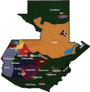
Although Spanish is the official language, it is not universally spoken among the indigenous population, nor is it often spoken as a second language. Twenty-one distinct Mayan languages are spoken, especially in rural areas, as well as several non-Mayan Amerindian languages, such as the indigenous Xinca, and Garifuna, an Arawakan language spoken on the Caribbean coast. According to Decreto Número 19-2003, there are 23 officially recognized Amerindian languages.[1]
The Peace Accords signed in December 1996 provide for the translation of some official documents and voting materials into several indigenous languages and mandate the provision of interpreters in legal cases for non-Spanish speakers. The accord also sanctioned bilingual education in Spanish and indigenous languages. It is common for indigenous Guatemalans to learn or speak between two to five of the nation's other languages, including Spanish.
Religion
Catholic Christianity was the only religion during the colonial era. However, Protestantism has increased markedly in recent decades, especially under the reign of dictator and evangelical pastor General Efraín Ríos Montt. More than one third of Guatemalans are Protestant, chiefly Evangelicals and Pentecostals.
The predominant religion is Catholicism. Protestantism and traditional Mayan religions are practiced by an estimated 33 percent and one percent of the population, respectively. It is common for traditional Mayan practices to be incorporated into Christian ceremonies and worship, a phenomenon known as syncretism.
The practice of traditional Mayan religion is increasing as a result of the cultural protections established under the peace accords. The government has instituted a policy of providing altars at every Mayan ruin found in the country so that traditional ceremonies may be performed there. There are also small communities of Jews, Muslims, and members of other faiths.
Education
The government runs a number of public elementary and secondary-level schools. These schools are free, though the cost of uniforms, books, supplies, and transportation makes them less accessible to the poorer segments of society. Many middle and upper-class children go to private schools. The country also has one public university (Universidad de San Carlos de Guatemala), and nine private ones. Guatemala has the lowest literacy rate in Central America; the problem of illiteracy poses a great challenge for Guatemala's future growth.
Notes
- ↑ 1.0 1.1 CIA, Guatemala The World Factbook. Retrieved March 8, 2024.
- ↑ 2.0 2.1 2.2 2.3 World Economic Outlook Database, October 2023 Edition. (Guatemala) International Monetary Fund. Retrieved March 8, 2024.
- ↑ Human Development Report 2021/2022 United Nations Development Programme. Retrieved March 8, 2024.
- ↑ Lyle Campbell, American Indian Languages: The Historical Linguistics of Native America (Oxford: Oxford University Press, 1997, ISBN 978-0195094275), 378 n. 10
- ↑ Tikal National Park UNESCO World Heritage List. Retrieved March 8, 2024.
- ↑ Guatemala - Terrestrial protected areas Index Mundi. Retrieved March 8, 2024.
- ↑ Montserrat Gorina-Ysern, OAS Mediates in Belize-Guatemala Border Dispute American Society of International Law. Retrieved March 8, 2024.
- ↑ 8.0 8.1 Truth Commission: Guatemala United States Institute for Peace. Retrieved March 8, 2024.
- ↑ Charles Babington, Clinton: Support for Guatemala Was Wrong The Washington Post (March 11, 1999). Retrieved March 8, 2024.
- ↑ Guatemala 1985 (rev. 1993) Constitute. Retrieved March 8, 2024.
- ↑ Rabinal Achi, Danse Drama, UNESCO, Intangible Cultural Heritage. Retrieved March 8, 2024.
ReferencesISBN links support NWE through referral fees
- Campbell, Lyle. American Indian Languages: The Historical Linguistics of Native America. Oxford: Oxford University Press, 1997. ISBN 978-0195094275
- Grandin, Greg. The Blood of Guatemala: A history of race and nation. Durham, NC: Duke University Press, 2000. ISBN 0822324954
- Human Rights Office of Archidiocese of Guatemala. Guatemala, Never Again! Maryknoll, NY: Orbis Books, 1999. ISBN 157075294X
- O'Kane, Trish. Guatemala in Focus: A Guide to the People, Politics and Culture. London: Latin America Bureau, 1998. ISBN 978-1566562423
- Woodward, Ralph L. A Short History of Guatemala. La Antigua, Guatemala: Editorial Laura Lee, 2008. ISBN 978-9992279724
External links
All links retrieved June 20, 2024.
- Guatemala The World Factbook.
- Guatemala Lonely Planet
- Guatemala Country Profile BBC
- Guatemala US Department of State
- Guatemala United States Agency for International Development (USAID)
Credits
New World Encyclopedia writers and editors rewrote and completed the Wikipedia article in accordance with New World Encyclopedia standards. This article abides by terms of the Creative Commons CC-by-sa 3.0 License (CC-by-sa), which may be used and disseminated with proper attribution. Credit is due under the terms of this license that can reference both the New World Encyclopedia contributors and the selfless volunteer contributors of the Wikimedia Foundation. To cite this article click here for a list of acceptable citing formats.The history of earlier contributions by wikipedians is accessible to researchers here:
The history of this article since it was imported to New World Encyclopedia:
Note: Some restrictions may apply to use of individual images which are separately licensed.


