| Yangtze River | |
|---|---|
| | |
| Basin countries | China |
| Length | 6,300 km (3,915 mi) |
| Source elevation | 5,042 m (16,542 ft) |
| Avg. discharge | 31,900 m³/s (1,127,000 ft³/s) |
| Basin area | 1,800,000 km² (695,000 mi²) |
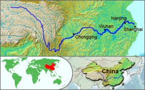
The Yangtze River or Chang Jiang (Simplified Chinese: 长江; Traditional Chinese: 長江; pinyin: Cháng Jiāng) is the longest river in Asia and the third longest in the world, after the Nile in Africa, and the Amazon in South America. The river is about 3,964 miles (6,380 km) long and flows from its source in a glacier in Qinghai Province, eastwards into the East China Sea at Shanghai, receiving water from over 700 tributaries along the way. It has traditionally been considered a dividing line between North and South China, although geographers consider the Qinling-Huai River line to be the official line of geographical division.
The Yangtze is one of the world's busiest waterways, flanked with industrial belts and high-tech development zones, and is a major transportation artery for China, connecting the interior with the coast. Cargo transportation on the river reached 795 million tons in 2005. Rapid modernization and economic development has accelerated problems such as industrial pollution, erosion and deforestation, and is accelerating the loss of native species. The Three Gorges Dam is the largest hydroelectric power dam in the world. It was conceived as a means of controlling floods, improving shipping, and providing electricity to millions of people, but may cause serious damage to the economy and the environmental health of the region.
Names

The name Yangtze River and various similar names such as Yangtse River, Yangzi River, and Yangtze Kiang are derived from Yangzi Jiang (Simplified Chinese: 扬子江; Traditional Chinese: 揚子江; pinyin: Yángzǐ Jiāng), which, beginning in the Sui Dynasty, was the Chinese name for the river in its lower reaches, specifically, the stretch between Yangzhou (扬州) and Zhenjiang (镇江). The name derives from the ancient ferry crossing Yangzi Jin (扬子津, meaning "Yangzi Crossing"). From the Ming dynasty, the name was sometimes written 洋子 (yángzĭ). Because it was the name first heard by missionaries and traders, this name was applied in English to the entire river. In Chinese, Yangzi Jiang is considered a historical or poetic name for the river. The modern Chinese name, Chang Jiang (长江/長江 Cháng Jiāng), literally means "long river" and may sometimes also be used in English.
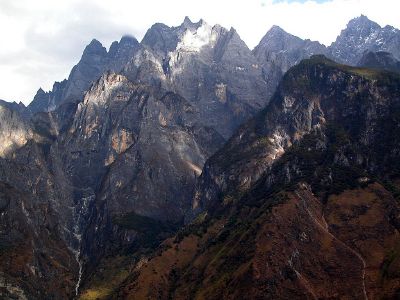
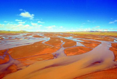
Like many rivers, the river is known by different names over its course. At its source it is called in Chinese the Dangqu (当曲, from the Tibetan for "marsh river"). Downstream it is called the Tuotuo River (沱沱河) and then the Tongtian River (通天河, "Pass to Heaven River"). Where it runs through deep gorges parallel to the Mekong and the Salween before emerging onto the plains of Sichuan, it is known as the Jinsha River (金沙江 Jīnshā Jiāng, "Golden Sands River").
The Yangtze was earlier known to the Chinese as simply Jiang (江 Jiāng), which has become a generic name meaning "river," or the Da Jiang (大江 Dà Jiāng, "Great River"). The Tibetan name for the river is Drichu (Tibetan: འབྲི་ཆུ་; Wylie: 'bri chu, "River of the Female Yak"). The Yangtze is sometimes referred to as the Golden Waterway.
Geography
The river originates in a glacier in the Dangla Mountains on the eastern part of the Tibetan plateau. It runs through the eastern part of Qinghai, turning southward down a deep valley at the border of Sichuan and Tibet to reach Yunnan. In the course of this valley, the river's elevation drops from above 16,404 ft (5,000 m) to less than 3,281 ft (1000 m).
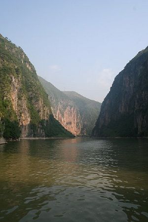
It enters the basin of Sichuan at Yibin. While in the Sichuan basin it receives several mighty tributaries, increasing its water volume significantly. It then cuts through Mount Wushan, bordering Chongqing and Hubei, to create the famous Three Gorges. Eastward of the Three Gorges, Yichang is the first city on the Yangtze Plain.
After entering Hubei, the Yangtze receives more water from thousands of lakes. The largest of these lakes is Dongting Lake, which is located on the border of Hunan and Hubei provinces, and is the outlet for most of the rivers in Hunan. At Wuhan it receives its biggest tributary, the Han River, bringing water from its northern basin as far as Shaanxi.
At the northern tip of Jiangxi, Lake Boyang, the biggest lake in China, merges into the river. The river then runs through Anhui and Jiangsu provinces, receiving more water from innumerable smaller lakes and rivers, and finally reaches the East China Sea at Shanghai.
Four of China's five main freshwater lakes contribute their waters to the Yangtze River. Traditionally, the upstream part of the Yangtze River refers to the section from Yibin to Yichang; the middle part refers to the section from Yichang to Hukou, where Boyang Lake meets the river; the downstream part is from Hukou to Shanghai.
History
The Yangtze river is important to the cultural origins of southern China. Evidence of human activity dataing as far back as sevn thousand years has been found in the Three Gorges area, initiating debate over the origin of the Chinese people.[1] In the Spring and Autumn Period, Ba and Shu were located on the western part of the river, covering modern Sichuan, Chongqing, and western Hubei; Chu was located on the central part of the river, corresponding to Hubei, Hunan, Jiangxi, and southern Anhui. Wu and Yue were located on the eastern part of the river, now Jiangsu, Zhejiang, and Shanghai. Although the Yellow River region was richer and more developed at that time, the milder climate and more peaceful environment made the Yangtze river area more suitable for agriculture.
From the Han Dynasty, the region of the Yangtze river became increasingly important to China's economy. The establishment of irrigation systems (the most famous one is Dujiangyan, northwest of Chengdu, built during the Warring States period) made agriculture very stable and productive. Early in the Qing Dynasty, the region called "Jiangnan" (that includes the southern part of Jiangsu, the northern part of Zhejiang, and the southeastern part of Anhui) provided 1/3-1/2 of the nation's revenue.
Historically, the Yangtze became the political boundary between north China and south China several times because of the difficulty of crossing the river. Many battles took place along the river; the most famous was the Battle of Red Cliffs in 208 C.E., during the Three Kingdoms period.
Politically, Nanjing was the capital of China several times, although it usually dominated only the southeastern part of China, such as the Wu kingdom during the Three Kingdoms period, the Eastern Jin Dynasty, and smaller countries in the Northern and Southern Dynasties and Five Dynasties and Ten Kingdoms periods. Only the Ming dominated most parts of China from its capital at Nanjing, though it later moved the capital to Beijing. The Republic of China capital was located in Nanjing during the periods 1911-1912, 1927-1937, 1945-1949.
Economy
The Yangtze is flanked with metallurgical, power, chemical, auto, building material and machinery industrial belts, and high-tech development zones. It plays an increasingly crucial role in the river valley's economic growth and has become a vital link for international shipping to the inland provinces. The river is a major transportation artery for China, connecting the interior with the coast.
The river is one of the world's busiest waterways. Traffic includes commercial traffic transporting bulk goods such as coal, as well as manufactured goods and passengers. As the tourism industry grows in China, luxury cruises on the river lasting several days are becoming popular, especially through the beautiful and scenic Three Gorges area.
Flooding
Flooding along the river has been a major problem. The rainy season in China is May and June in areas south of Yangtze River, and July and August in areas north of it. The huge river system receives water both from southern and northern flanks, which causes its flood season to extend from May to August. The relatively dense populations of the prosperous cities along the river make the floods more deadly and costly. The most recent major floods were the 1998 Yangtze River Floods, but more disastrous were the 1954 Yangtze river floods, which killed around 30,000 people. Other severe floods included those of 1911 which killed around 100,000, 1931 (145,000 dead), and 1935 (142,000 dead).
Environment
Pollution and heavy shipping traffic on the Yangtze have taken a heavy toll on native species. The Yangtze is home to (at least) two critically endangered species, the Chinese Alligator and the Chinese Paddlefish. In December of 2006, the Baiji Chinese River Dolphin was declared extinct after an extensive search of the river revealed no signs of the dolphin's inhabitance. In 2007, fears were expressed that China's Finless Porpoise, known locally as the jiangzhu or "river pig," might follow the baiji into extinction, and calls were made for action to be taken to save the porpoise. About 1,400 porpoises are left; between 700 and 900 in the Yangtze, and another 500 in Poyang and Dongting Lakes. The porpoise population is dropping at a rate of 7.3 percent per year, and 2007 numbers are less than half of the number counted in 1997.
Heavy river traffic on the Yangtze has driven the porpoise into the lakes. On Poyang Lake, the largest freshwater lake in China, sand dredging has become an important source of revenue over the last few years. High-density dredging projects are the principal cause of the death of the local wildlife population, clouding the water and disrupting the ecological balance. Porpoises, unable to see as far as they once could, are forced to rely on their highly-developed sonar systems to avoid obstacles and look for food. Large ships enter and leave the lake at the rate of two every minute, making it difficult for the porpoises to “hear,” and stopping them from swimming freely from one bank to the other. [2]
About 30 percent of river's major tributaries, such as Minjiang, Tuojiang, Xiangjiang, and Huangpu, are heavily polluted by massive quantities of ammonia, nitrogen, phosphorous, and other chemicals which have caused a significant reduction of the fish catch. The Yangtze is particularly polluted in Hubei (Shashi).
Three Gorges Dam
The Three Gorges Dam across the Yangtze River is the largest hydroelectric river dam in the world. The world's largest power station in terms of installed capacity (22,500 MW),[3][4] the Three Gorges Dam generates 95±20 TWh of electricity per year on average, depending on the amount of precipitation in the river basin. After the extensive monsoon rainfalls of 2020, the dam's annual production reached nearly 112 TWh, breaking the previous world record of ~103 TWh set by Itaipu Dam in 2016.[5]
The dam's body was completed in 2006; the power plant was completed and fully operational by 2012, when the last of the main water turbines in the underground plant began production.
The installation of ship locks is intended to increase river shipping from 10 million to 50 million tonnes annually, with transportation costs cut by 30 to 37 percent. Shipping is also safer, since the gorges are notoriously dangerous to navigate.
As with many dams, there has been debate over the costs and benefits of the Three Gorges Dam. Although there are economic benefits such as flood control and hydroelectric power, there are also concerns about millions of people displaced by the rising waters, in addition to concerns over the loss of many valuable archaeological and cultural sites, as well as the effects on the environment.
This is the largest comprehensive irrigation project in the world, and has a significant impact on China's agriculture. Its proponents argue that it will protect people living along the river from floods that have repeatedly threatened them in the past, and will offer them electricity and water transport, though at the expense of permanently flooding many existing towns (including numerous ancient cultural relics) and causing large-scale changes in the local ecology.
Major Cities Along the River
- Panzhihua
- Yibin
- Luzhou
- Chongqing
- Yichang
- Jingzhou
- Shashi
- Shishou
- Yueyang
- Xianning
- Wuhan
- Ezhou
- Huangshi
- Huanggang
- Chaohu
- Chizhou
- Jiujiang
- Anqing
- Tongling
- Wuhu
- Hefei
- Chuzhou
- Maanshan
- Taizhou
- Yangzhou
- Zhenjiang
- Nanjing
- Nantong
- Shanghai
Crossings
- Liuku Nu River Bridge
- Jiujiang Yangtze River Bridge (opened 1992)
- Baidicheng Suspension Bridge
- Nanjing Yangtze River Bridge (road/rail bridge)
- Caiyuanba Bridge
- Chaotianmen Bridge
- Chongqing 2nd Bridge over the Yangtze River
- Masangxi Bridge
- Shibanpo Bridge
- Wushan Bridge
- Fengdu Suspension Bridge
- Maochaojie Bridge
- Wanxian Bridge
- Wuhan Yangtze River Bridge (road/rail bridge, opened 1957)
- Second Wuhan Bridge (opened 1995)
- Wuhan Baishazhou Bridge (opened 2000)
Tributaries
The Yangtze River has over 700 tributaries but the principal tributaries are the following:
- Yalong River
- Minjiang River
- Daduhe River
- Tuojiang River
- Jialing River
- Wujiang River
- Qingjiang
- Xiangjiang
- Lishui (Li)
- Zijiang (Zi)
- Yuanjiang (Yuan)
- Han River
- Ganjiang River
- Huangpu River
Notes
- ↑ H. Wanpo, et al., Early Homo and associated artefacts from Asia Nature 378 (1995): 275–278. Retrieved December 3, 2024.
- ↑ Zhang Kejia, Poyang Lake: saving the finless porpoise Dialogue Earth (March 9, 2007). Retrieved December 3, 2024.
- ↑ Cutler J. Cleveland and Christopher G. Morris, Handbook of Energy Volume II: Chronologies, Top Ten Lists, and Word Clouds (Elsevier Science, 2013, ISBN 978-0124170131).
- ↑ Robert Ehrlich, Harold A. Geller, and John R. Cressman, Renewable Energy: A First Course (CRC Press, 2022, ISBN 978-0367768379).
- ↑ Three Gorges Dam sets power generation record in 2020 China Daily (January 1, 2021). Retrieved December 3, 2024.
ReferencesISBN links support NWE through referral fees
- Chetham, Deirdre. Before the deluge the vanishing world of the Yangtze's Three Gorges. New York, NY: Palgrave Macmillan, 2002. ISBN 0312214170
- Cleveland, Cutler J., and Christopher G. Morris. Handbook of Energy Volume II: Chronologies, Top Ten Lists, and Word Clouds. Elsevier Science, 2013. ISBN 978-0124170131
- Ehrlich, Robert, Harold A. Geller, and John R. Cressman. Renewable Energy: A First Course. CRC Press, 2022. ISBN 978-0367768379)
- National Geographic Society (U.S.). Journey into China. Washington, DC: National Geographic Society, 1982. ISBN 0870444379
- Van Slyke, Lyman P. Yangtze: nature, history, and the river. A Portable Stanford Book. 1988. ISBN 0201088940
- Winchester, Simon. The River at the Center of the World: A Journey up the Yangtze & Back in Chinese Time. Holt, Henry & Company, 1996. ISBN 0805038884
External links
All links retrieved December 3, 2024.
- Yangtze World Wildlife Fund (WWF).
- Yangtze River A Visual Sourcebook of Chinese Civilization
- Yangtze River: Lifeline for Many Communities Rivers Are Life
Credits
New World Encyclopedia writers and editors rewrote and completed the Wikipedia article in accordance with New World Encyclopedia standards. This article abides by terms of the Creative Commons CC-by-sa 3.0 License (CC-by-sa), which may be used and disseminated with proper attribution. Credit is due under the terms of this license that can reference both the New World Encyclopedia contributors and the selfless volunteer contributors of the Wikimedia Foundation. To cite this article click here for a list of acceptable citing formats.The history of earlier contributions by wikipedians is accessible to researchers here:
The history of this article since it was imported to New World Encyclopedia:
Note: Some restrictions may apply to use of individual images which are separately licensed.


