British Virgin Islands
| |||||
| National motto: The Land, The People, The Light | |||||

| |||||
| Official language | English | ||||
| Political status | Non-sovereign, Overseas territory of the UK | ||||
| Capital | Road Town | ||||
| Governor | Tom Macan | ||||
| Chief minister | Orlando Smith | ||||
| Area - Total - % water |
Ranked 176th 153 km² 1.6% | ||||
| Population - Total (2002) - Density |
Ranked 175th 21,730 260/km² | ||||
| Currency | US dollar | ||||
| Time zone | UTC -4 | ||||
| National anthem | |||||
| Internet TLD | .vg | ||||
| Calling Code | 1-284 | ||||
The British Virgin Islands (or BVI) is an overseas territory of the United Kingdom.
It is a group of over 50 islands and cays located in the Caribbean. They include Tortola, Virgin Gorda, Anegada, Jost Van Dyke, Great Camanoe, Guana Island, Peter Island, Salt Island, Beef Island, Cooper Island, Ginger Island, Norman Island, and many other small islands which are clustered around the Sir Francis Drake Channel.
A few of the islands are privately owned. Necker Island is owned by Sir Richard Branson and is now an exclusive holiday spot.
The United Nations Committee on Decolonization includes the British Virgin Islands on the United Nations list of Non-Self-Governing Territories.Template:An
History
- Main article: History of the British Virgin Islands
The British Virgin Islands were sighted and named by Christopher Columbus on his second voyage in 1493. They were first settled in 1648 by the Dutch and were annexed by England soon after in 1672. They were called the "Virgin Islands" until "British" was added at the end of World War I after the United States had purchased the nearby Danish West Indies and renamed them as the U.S. Virgin Islands.
Geography
- Main article: Geography of the British Virgin Islands
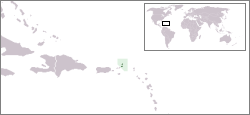
About 50 small Caribbean islands comprise the British Virgin Islands; around 16 are inhabited. They are located a few miles east of the U.S. Virgin Islands. The North Atlantic Ocean lies to the north of the islands, and the Caribbean Sea lies to the south.
The largest islands of the group are Tortola, Virgin Gorda, Anegada, and Jost Van Dyke. Road Town, the capital and largest town, is situated on Tortola.
Economy
- Main article: Economy of the British Virgin Islands
The economy of the British Virgin Islands is one of the more prosperous ones of any of the Caribbean states, with a GDP per capita of around $15,000.
The British Virgin Islands is highly dependent on tourism, which accounts for 45% of national income. The islands are a popular destination for U.S. citizens, with around 350,000 tourists visiting annually (1997 figures). Tourists frequently go to the numerous white sand beaches, visit The Baths on Virgin Gorda, snorkel the coral reefs near Anegada, experience the well-known bars on Jost Van Dyke, or charter yachts to explore the less accessible islands.
Substantial revenues are also generated by the registration of offshore companies. As of 1997, 250,000 companies were so registered.
The economy is closely linked with that of the larger U.S. Virgin Islands to the west, and the islands' currency, since 1959, is the US dollar.
Transport
- Main article: Transportation on the British Virgin Islands
Being a small group of islands, transportation is limited. There are 113km of roads. The main airport is located on Beef Island, near Tortola. Virgin Gorda and Anegada have their own smaller airports. The main harbour is in Road Town.
External links
Maps of The British Virgin Islands from Caribbean-On-Line.com
- Map of The British Virgin Islands
- Map of Tortola
- Map of Road Town
- Map of Jost Van Dyke
- Map of Virgin Gorda
- Map of Anegada
Credits
New World Encyclopedia writers and editors rewrote and completed the Wikipedia article in accordance with New World Encyclopedia standards. This article abides by terms of the Creative Commons CC-by-sa 3.0 License (CC-by-sa), which may be used and disseminated with proper attribution. Credit is due under the terms of this license that can reference both the New World Encyclopedia contributors and the selfless volunteer contributors of the Wikimedia Foundation. To cite this article click here for a list of acceptable citing formats.The history of earlier contributions by wikipedians is accessible to researchers here:
The history of this article since it was imported to New World Encyclopedia:
Note: Some restrictions may apply to use of individual images which are separately licensed.
